|
|
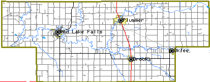
TOUR STOPS : WESTERN RED LAKE COUNTY
TOUR STOPS : EASTERN RED LAKE COUNTY
Introduction
The Red Lake Falls Area has a rich and varied history in which the Red Lake and Clearwater Rivers have played a central role. These rivers provided the proper habitat for a wide range of wildlife. Over two hundred years ago this wildlife attracted the Chippewa (Ojibway) Indians from the great lakes region who were following the fur trade business west. By 1798 Jean Baptiste Cadotte had established a trading post near the junction of the two rivers in or near the present day Sportsman's Park in Red Lake Falls.
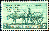
As oxcarts began crossing the area while transporting goods between St. Paul, Minnesota and the Selkirk or Red River Colony (present day Winnipeg, Manitoba, Canada) the "Old Crossing" of the Red Lake River near Huot, Minnesota, became a place of historical importance. At this site in 1863 a peace treaty was signed between the Red Lake and Pembina bands of the Chippewa Indians, and the U.S. Government. This treaty ceded to the United States nearly 11 million acres of some of the most fertile land in the world.
In 1876 the famous metis (of mixed French and American Indian blood) guide, Pierre Bottineau, brought the first settlers to the area, 119 families of French Canadian descent who founded the towns of Red Lake Falls and Gentilly. Settlers of European descent followed, attracted to the same waters that attracted the Indians and trappers before them. Newspapers of the time advertised the abundant supply of water power provided by the two rivers.
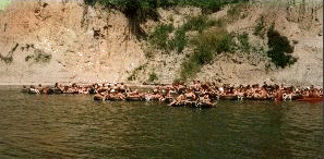
These same waters still maintain their powers of attraction as thousands of vacationers come each summer to enjoy the beautiful scenery while floating in inner tubes on the Red Lake River .
This two to three hour Self Tour is designed to introduce you to the diverse and interesting history of the area. There are 13 "stops" covering approximately 40 miles, over which you will learn of the geology, geography, exploration and settlement of the area. Relax and enjoy the beauty of the area as you journey into the past.
STOP #1 RED LAKE FALLS
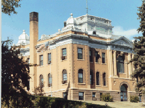
RED LAKE COUNTY COURTHOUSE:
|
DIRECTIONS: West side of highway 32, turn west on First Street then left (north) on XXXXX Street before St. Joseph's Catholic church |
|
Red Lake County was originally part of Polk County, which was established in 1858. Polk County included nearly the entire northwestern corner of Minnesota, representing the present counties of Polk, Norman, Red Lake and Pennington, and parts of Beltrami, Clay, Becker and Hubbard Counties. Its total area covered over 7,000 miles.
Gradually legislation diminished the size of the county until nothing remained but the territory now comprising Polk, Red Lake and Pennington Counties. It was still large, in fact ranking fourth in size among all counties in the state.
A 10-year battle had developed to separate Polk and Red Lake into independent counties. The main reason for the battle, as expressed by supporters of a new Red Lake county, was that Crookston, being the county seat of Polk, drew all the strength of the county to itself, but rarely did anything of service for the people. Outlying towns and farming districts were scarcely recognized except for the payment of taxes.
In the 1896 election three new counties were formed from within Polk, after receiving the necessary votes to become independent. However, the boundaries of Red Lake, Mills and Columbia Counties overlapped and each had a different designated county seat. After a diligent fight in St. Paul by several Red Lake Falls residents, Red Lake was duly declared a county by Gov. David M. Clough on Christmas Eve, 1896. In the proposition to create Red Lake County, five men had been named as its first board of commissioners. These men traveled to Crookston, arriving at 3 a.m., Dec. 26, at the office of the clerk of court and filed certified copies of the governor's proclamation with the commissioners' oaths of office endorsed on the back.
For more, see article by Charles Boughton: http://nmin.ardc.org/history/rlsep.asp
Soon after Red Lake was officially declared a county, the residents of Thief River Falls began a campaign to name their city as the county seat. The law prohibited a change in the county seat for five years, yet this campaign prevented the construction of a decent courthouse.
Finally, in April of 1905, a petition with 2,006 signatures was presented at the county auditor's office by officials from Thief River Falls in an effort to move the seat to their county. Lawsuit after lawsuit was tried as Red Lake Falls officials attacked the legality of the petition. This battle lasted five years until suspected arson finally brought the matter to a head.
On April 23, 1909 the county courthouse was completely destroyed by a mysterious fire. It was rumored that the local fire brigade arrived strangely late and records show members of the brigade joked about the incident at the scene of the fire, winking at each other and commenting on how the blaze could have started. The fire was blamed on a defective chimney and temporary offices were set up in the Healy Land Co. building also in Red Lake Falls.
Plans for a new courthouse were drawn and a resolution for the sale of bonds to raise money for construction was passed. The people of Thief River Falls brought a court action against the board of commissioners attempting to prevent construction, but the case was lost.
While the courthouse was under construction the county was severed to create Pennington County by the Minnesota legislature and Thief River Falls was named the county seat. Shortly after this the Minnesota Supreme Court ruled that Pennington County residents would have to help pay for the Red Lake County courthouse since the bond issue, which had been passed by the Red Lake County Commissioners was still legally binding on the residents of Pennington County since they had been Red Lake residents at the time the issue was passed. The cornerstone was laid on June 11, 1910 and construction was completed by early February, 1911.
|
The building once had a large central dome on top. Commissioners voted to remove the dome in 1947 because it had taken a tremendous beating from the elements resulting in serious leakage. |
|
The courthouse is significant for its central role in the affairs of Red Lake County and for its distinctive style and location. Its hilltop location and its good integrity, despite the absence of the dome, make it the most imposing building in the community of Red Lake Falls. It was for these reasons that the courthouse was entered into the National Register of Historic Places in May, 1983.
CADOTTE TRADING POST SITE
DlRECTI0NS: From the courthouse go back to Highway 32, turn north (left)and go one block to Bottineau Avenue. Turn west (left), go one mile then turn left into the Sportsman's Park.
The first trading post in the area was erected near this site, at the junction of the Red Lake and Clearwater Riven, by Jean Baptist Cadotte Jr., an employee of the Northwest Fur Trading Company. (The actual site is unknown but believed to be across the clearwater river from THE Al Buse Sportsman's Park.) We know that Cadotte spent the winter of 1797-98 here from the writings of David Thompson, a geographer and surveyor who took shelter in the cabin during a spring snow storm (1798). Thompson wrote: "Mr. Baptiste Cadotte was about thirty-tive yean of age. He was the son of a French gentleman by a native woman, and married to a very handsome native woman, also the daughter of a Frenchman. He has been well educated in Lower Canada and spoke fluently his native language with Latin, French and English. "
(The following paragraphs are taken from "The French- Canadian Presence in the Northwest and the Very Early Beginnings of Red Lake Falls and Red Lake County" by Virgil Benoit, in A Histo~ of Red Lake County, edited by Anne Healy and Sherry Kankel, Taylor Publishing Co., Dallas, 1976. For more see article by Virgil Benoit and http://nmin.ardc.org/history/rlindex.asp )
EXPLAIN /REFERENCE QUOTES???? ...In 1789 the Hudson's Bay company proposed a "series of posts radiating out from Osnaburgh southward -at Sturgeon Lake, Red Lake, Portage de 1'Isle and Rainy Lake. .." the establishment of a post at Red Lake (not Red Lake Falls) meant that trade would also develop along the Red Lake and Red Rivers since they formed the waterway to Pembina, North Dakota, and the posts of the north. Moreover, the area of the Red Lake River which extended into the regions where buffalo grazed was highly strategic in the development of the fur trade. In establishing posts along this route the Hudson's Bay Company was securing for itself the pemmican, or dried buffalo meat, so necessary for its traders. .." Thus the Red Lake River posts were meant to be a strategic hold against the traders of competitive fur companies, who, like the traders of the Hudson's Bay Company sought to secure their trade in the far northwest. By 1826 there were as many as seventeen training posts in the upper Mississippi country.
"To Jean Baptiste Cadotte Jr. is given the credit for completely opening to the fur traders the region about the upper Mississippi. " Jean Baptiste had followed in the footsteps of his father, the fur trader and partner of Alexander Henry WHO IS HE? Jean Baptiste Cadotte, Jr. spent the winter of 1797-98 at the strategic forks of the Red Lake and Clearwater Rivers, or at the present site of the town of Red Lake Falls. "Mr. Cadotte in the employ of the Northwest Company, probably spent the winter of 1794-95 at Red Lake and the next year at Cedar or Cass Lake, while the season following, 1796-97, was passed at Red Lake once more. ..He was in charge the next winter of the trading house of the Northwest Company on the present site of the town of Red Lake Falls." On March 25, 1798 the geographer and surveyor David Thompson, who like Cadotte was in the employ of the Northwest Company, visited Cadotte's house at the fork of the Red Lake and Clearwater Rivers. About his visit Thompson wrote: "Mr .Baptiste Cadotte was about thirty-five years of age. He was the son of a French gentleman by a native woman, and married to a very handsome native woman, also the daughter of a Frenchman: He had been well educated in Lower Canada, and spoke fluently his native Language, with Latin, French and English. I had long wished to meet a well educated native, from whom I could derive sound information for I was well aware that neither myself, nor any other Person I had met with, who was not a Native, were sufficiently masters of the Indian Languages. As the season was advancing to break up the Rivers, and thaw the snow from off the ground, I inquired if he would advise me to proceed any farther with Dogs and Sleds: he said the season was too far advanced, and my further advance must be in Canoes.
Because of the severity of the spring thaw and rain which accompanied it, Thompson returned to Cadotte's house March 31 at which time he spoke with the Chippewa chief of the Red Lake Indians and observed some Indian dances. "The course of this River is from south westward until it is lost in the Plains, the groves are at a considerable distance from each other, by no means sufficient for the regular Farmer, but may become a fine pastoral country , but without a market, other than the inhabitants of the Red River." Thompson left Cadotte's house on April 9 with his crew of three French Canadians and the wife of one of them, a native woman. They took the Clearwater River since they were traveling in a birch canoe and the Red Lake River still had ice on it from the Lake.
This junction of the Red Lake and Clearwater rivers is also significant in Native American legend. For more see: oldchief.htm
STOP #2 THE PERRAULT SCHOOL
DlRECTIONS: From Stop #2, return to Highway 32, and turn south (right). The Perrault School is on the west (right) side of Highway 32, four miles south of Red Lake Falls.
The Perrault School, District #32, was one of six in Lake Pleasant township of Red Lake County. Classes were taught here for 68 years (from 1880 to 1948) when the district was consolidated with that or Red Lake Falls. According to A Historv of Red Lake County (1976) in 1901 District #32 "had Josephine Kaus as a teacher with thirty- one students. Her salary was $30.00 per month. " The school building has served as the Lake Pleasant Town Hall since 1881. The school house has been restored as an interpretive center for early American schools. Please have a look around. The building is locked but you can get a good look through the windows.
STOP #3 GLACIAL LAKE AGASSIZ SHORELINE
|
DIRECTIONS: From the Perrault School continue south on Highway 32 one mile then go west (right) on county Road 14 (gravel) five miles. Stop on ridge just past a small stream/gully. |
|
(The following is taken from Centennial History of Polk County by T. M. McCall, McGarry Publishing Co., Crookston, MN. 1961.)
It may be difficult for people today to believe that great glaciers once moved down from the north and that these great sheets of ice moved across the length of Minnesota and extended down into Iowa~ that the great lobes of ice, as they planed off the surface of the land, left great deposits of soil and rocks which formed terminal moraines which held back the water as the ice melted. (Moraines are accumulations of debris along the edges of glaciers.) The enormity of the ice sheet and the volume of water challenges the imagination as geologists unfold the history to us.Mute evidence that a great ice sheet did move over Minnesota can still be seen today in the planed-off outcroppings of the original granite near Clementson, and the bald granite ridges in southern Ontario, Canada. Other cumulative evidence of the action of the ice sheet lobe in this area can be seen in the terminal and lateral moraines of the southern counties of the Red River Valley and in the definite shore lines of the receding glacial lake which are apparent on both the Dakota and Minnesota sides of the Red River Valley.
A famed geologist, Warren Upham, did pioneer work in tracing shore lines of the great glacial lake for the Minnesota Geological Survey and the United States Geological Survey. The name Lake Agassiz was given this prehistoric glacial lake by Warren Upham in 1879 in the Eighth Annual Report of the Minnesota Geological Survey .According to Upham, the first true explanation of the lake's existence was presented by a geologist professor of the university in 1872. Upham reports, "while the retreating ice sheet served as a dam to prevent water from the melting ice to flow northward, the overflow did go south through the Lake Traverse and Big Stone Lake area, through Brown's Valley to cut out the channel of what is now known as the Minnesota River Valley .II This glacial river, which carved out the Minnesota River Valley , was named River Warren by Upham.
Another famed geologist, who collaborated with and followed up the work ofUpham, was J. E. Todd. Todd, in Chapter V of the 1896-97 Report of the Minnesota Geological Survey, Volume 4, gives an excellent report on the geologic history of Norman and Polk (including Red Lake) counties.
In discussing the history of the glacial Lake Agassiz, Todd reports,. .."In its (the glacier's) recession, we suppose that it had periods of halting and possibly advancing for short distances, which has, as before explained, resulted in the accumulation of moraines. Between the Red River lobe, as we may call it, and the Lake Superior lobe, which occupied the upper Mississippi region, there was at one time no distinct separation upon the surface of the ice sheet, but as they melted away their margins would very naturally be more and more separated along the height of land or ridge forming the divide between the Mississippi basin and that of the Red River."
In tracing the shore lines of beaches of glacial Lake Agassiz, Upham found that their elevation of the highest crest of the Herman beach in Polk County was 1,173 feet above sea level, which would indicate that a water depth of 300 feet stood over what is now Crookston. ...Upham states: " Several successive levels of Lake Agassiz are recorded by distinct and approximately parallel beaches of sand and gravel due to the gradual lowering of the outlet by the erosion of the channel at Brown's Valley and these are named in their descending order, Herman, Norcross, Tintah, Campbell and McCauleyville beaches, because they pass through or near these towns. "
For more information see:
STOP #4 Huot Area
THE "OLD CROSSING" OF THE PEMBINA TRAIL..
CHANGE directions DIRECTIONS: From St. Peter's Church return to County Road 11 and go back (east) six miles to County Road 3. Turn west (left) on County Road 3 and go one half mile to the bridge over the Red Lake River.
This bridge is located just downstream of the site of the Old Crossing, where from 1844 to the 1870s thousands of ox- drawn two wheel carts crossed the Red Lake River while hauling goods between St. Paul, Minnesota, and the Red River Colony (Winnipeg, Manitoba, Canada). This particular trail became known as the "Woods Trail" because of the forested areas south of present day Detroit Lakes through which it passed, but is known locally as the Pembina Trail. The Woods Trail which passed entirely through lands once controlled by the Chippewa Indians became popular to oxcart drivers when the more westerly trail, along the Red River in North Dakota, came under attack by the Dakota Sioux Indians.
(The following is taken from The Red River Trails -Oxcart Routes Between St. Paul and the Selkirk Settlement 1820- ~ by Rhoda R. Oilman, Carolyn Oilman and Deborah M. Stultz, published by the Minnesota Historical Society, 1979. )
The Old Crossing of the Red Lake River was a place of some importance in Minnesota history. Claimed by both the Dakota (Sioux) and the Ojibway (Chippewa), the valley of the Red Lake River was a perilous region where an attack was always expected and often delivered. At least one group of travelers was requested by its metis guides not to fire any guns within 10 or 12 miles of the river so as not to "attract the attention of any stray parties of Sioux who might possibly be within hearing." In the 1850s Joe Rolette built a trading house at the Old Crossing and proposed to found a "magnificent city" to be called Douglas. A compliant state legislature, of which Rolette was a member, designated the townsite as the seat of Polk County in 1858, cooly ignoring the fact that the land belonged to the Ojibway. But the tribe balked, refusing to let Rolette operate a ferry there, and his plan was stillborn.The Old Crossing was a habitual camping spot despite its location in a war zone. From the river bluff on the north side, where Red Lake County Road 104 (now County Road 3) climbs the hill, the trail commanded a beautiful view of the stream and "La grande Prairie -a treeless waste stretching out before us until lost in the distance." The "thick groves of Oak, Poplar, Elm, Whitewood and Ironwood" through which the trail wound down to the ford provided all the firewood a party could want. Despite the beauty of the surroundings, one wayfarer probably did not sleep well, for" All night long the wolves made doleful music in the wood on the other side of the. ..River" while the "stream rolled on in heavy flood a few yards below the willows that sheltered our tents, and as I watched its swift and turbid current, I could not but wish that everything were safe across. " (Note: wolves have recently returned to this area.)
Getting over the Red Lake River could be a difficult undertaking at any time of year. A well-equipped party in 1857 had no problems, they sent their baggage across in two small canoes, swam their horses, and hauled their carts across with ropes. But those who made the attempt in high water and without canoes had to make careful preparations. "We emptied the cart," wrote a journalist in 1859, "laid bars on top, piled our goods and chattels upon them, weighting the upper side so that the current might not tip the cart over, and, one of us standing upon the same side, with (our horse) harnessed between the shafts, we entered the water."
But once in the water, the difficulties had only begun. To those who did not know "the secret of the ford," the crossing might well prove disastrous. A Canadian traveler described his puzzlement at seeing "the deep tracks of loaded carts (going) straight over the gravel shore and into the water" with similar tracks leading out directly opposite on the far side -yet in between the river was far too deep to ford. After several hours of effort, he at last discovered the key: "the carts had indeed entered straight into the water at the foot of the sloping bank we had descended, but, once in, they had turned up-stream to make the crossing in a horse shoe fashion which brought them out directly on the opposite side, where again a sloping bank formed the best path for ascent and descent." Even this method of crossing was impossible when the water was high. "In spring the river is at least twenty feet deep here," one passer-by noted; "at this season cattle are made to swim over and vehicles are rafted across." Rolette's ferry would have been a welcomed convemence.
SHRINE OF THE BLESSED VIRGIN
DlRECTIONS: Continue across the bridge and turn north (right) immediately. At the next intersection turn east (right). Look for the shrine on a hill on the north (left) side of the road. Turn right into the Old Crossing Treaty County Park just BEFORE the shrine steps.
This shrine was built by Father Ernest Bossus, pastor of St. Dorothy's Catholic Church from 1926 to 1935. The roots of St. Dorothy's Parish go back to the Huot area, where Father Pierre Champagne offered mass at the home of Louis Huot as early as 1880. At that time there were about 25 Canadian families located in the area. A church, St. Aloysius, was built at Huot in 1883. In 1919 a new church was built in the village of Dorothy (5 miles north) and the St. Aloysius Church was closed. Father Bossus' sight failed in his last years at Dorothy but his eyesight was successfully restored by a cataract operation. In Thanksgiving, he built a shrine in honor of the Blessed Virgin on this knoll across the road from Huot State Park. Dorothy's parishioners still gather annually for services at the Shrine.
OX CART TRAIL MARKER
|
DlRECTIONS: Just inside the Old Crossing Treaty County Park across .from the Shrine of the Blessed Virgin. You should already be there. |
|
This marker is on the site of the Woods (Pembina) Oxcart Trail. If you can brave the mosquitoes, you can see the indentation of the actual trail through the woods ahead of you (see map).
POST OFFICE TREE
DlRECTI0NS: Continue through the park to the boat ramp on the Red Lake River. Ahead of you is a large Cottonwood tree.
Within the Old Crossing Treaty County Park, along the river just north of the boat ramp, is a large Cottonwood tree which was once used as a post office for early settlers. Oxcart drivers would collect or deposit letters in a box nailed to the tree as they passed through the area. The "Old Crossing" (Stop # 6) of the Red Lake River was near this tree.
OLD CROSSING TREATY MEMORIAL
|
DIRECTIONS: Just before you leave the park is a statue of a Chippewa Indian, on your left. |
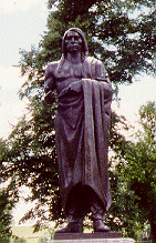 |
(The following is taken from "The Old Crossing Treaty" by John Saugstad, in The Old Crossirig Treaty Memorial - Dedicatory Exercises, the program for the dedication of the Old Crossing Treaty Monument, June 25, 1933.)
Seventy years ago (133 years from 1996), while the United States was engaged in a bloody civil war in which many Indian tribes were involved, an invitation was sent out from Washington to the Red Lake and Pembina bands of the Chippewa Indians were to assemble at the Old Crossing for a Pow- Wow where a treaty would be agreed upon whereby the said Indians would cede to the United States nearly all of that vast tract of land known as the Red River Valley of the North.This message was passed on to the respective bands by the United States agents, the Indian chiefs and headmen together with a command from the Chiefs to assemble at the Old Crossing of the Red Lake River during the middle part of September, 1863.
At about the middle of September, the Red Lake bands of the Chippewa Indians assembled at the designated crossing and there pitched their wigwams. With them came U. S. Agent Morril (Ashley C. Morril). To this same place came the official party with Alexander Ramsey, representing the U.S. Government, escorted by a small detachment of U. S. soldiers and pitched their tents on the 21st day of September. On the 23rd of September the Pembina band of Indians arrived and the first session of the treaty council was held that day.
The two Indian bands were encamped on a beautiful, grassy lowland near the Red Lake River, and only a short distance from the ford or "Old Crossing" . The white men were encamped on a small hillock between the two Indian bands.
For about two weeks or until October second the chiefs and headmen bargained and discussed the terms of the treaty, always seeking better terms and conditions for their respective bands. On October first all chiefs had agreed to the terms of the treaty except Chief May-dwa-gun-on-ind, of the Red Lake bands, who steadily opposed the terms and when the chiefs left the council on the evening of October 1 st " all hope of effecting a treaty with the Red Lake Indians seemed to be at an end." The following day, however, the council assembled again without May-dwa-gun-on-ind, and after some further discussion lasting about three and one-half hours, Red Lake Chief, Mons- o-Mo "touched the pen". Five other chiefs, eight warriors and one head warrior followed him in signing as did the commissioners, Alexander Ramsey and A. C. Morril, and witnesses. This was October 2nd, 1863.
On October 3rd the treaty goods, presents, flags, and provisions were distributed, and" on the fourteenth day from our arrival at the treaty grounds, the expedition started on its return home".
Thus the Red Lake and Pembina bands of the Chippewa Indians ceded to the United States of America that most wonderful and fertile land that became known as the "bread and butter basket" of the nation, making it possible for thousands of families to acquire homes.
Text of Old Crossing Treaty 1863
http://wwwvms.utexas.edu/~wos/REDLAKE/Cross1.html
http://www.councilfire.com/treaty/treat321.htm
The ceded area is approximately 180 miles long, north and south, and approximately 127 miles wide, east and west, at the extreme length and width, containing approximately 11,000,000 acres according to Alexander Ramsey's estimate and report. For this tract the United States paid $510,000.
Article One of the treaty reads as follows: "The peace and friendship now existing between the United States and Red Lake and Pembina bands of the Chippewa Indians shall be perpetual " .
Thus the "Old Crossing" of the Red Lake River, where thousands of oxcarts passed, and where the making and signing of the Old Crossing Treaty occurred, is one of the outstanding historical places of Northwestern Minnesota and Northeastern Dakota, and the second day of October, 1863, has become and will remain an outstanding historical date for the states of Minnesota and North Dakota.
STOP #5 "TUBERS' ATTRACTED TO THE RED LAKE RIVER
|
DlRECTI0NS: From stop # 12 continue past the cemetery up the hill to County Road 18 (paved). Turn east (right) and follow County Road 18 east and north to County Road 13. Continue east (straight) .five miles on county Road 13. |
|
STOP #6 PIERRE BOTTINEAU GRAVESITE
DlRECTIONS: From Stop # 12 proceed along County
Road 13 to Highway 32 in Red Lake Falls. Turn
left on Highway 32, go one block, then turn right
onto County Road 1. Follow County Road lone mile.
Turn left into St. Joseph's cemetery. The Bottineau grave
site is near the cemetery entrance.
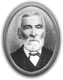
If anyone person stands out in the early history of Red Lake
Falls it is Pierre Bottineau. Born in 1817 in Red River country he
was the son of a French man and a Chippewa woman. He learned the ways
of the woods and prairies while a child trapping with his voyageur
father . Fluent in French, English, Chippewa, Cree, Mandan and
Winnebago, Bottineau worked for various agencies as interpreter and
guide. In 1876 he, and two of his sons, came to what is now Red Lake
Falls and staked a claim along the Clearwater river. He encouraged
many French Canadians from St. Paul, Minnesota and the Red River
Colony (Winnepeg, Manitoba, Canada) areas to settle here. He died in
1895 and was buried in the Cyr Cemetery west of Red Lake Falls. In
1978 his remains, and those of four members of his family, were moved
to this site by the Red Lake County Historical Society.
During those years, he made several trips for Henry H. Sibley, agent of the American Fur Company, the man who was to become Minnesota's first governor, and assisted Franklin Steele in filling government contracts, notably the one supplying Fort Ripley on the upper Mississippi. In 1862 he was in North Dakota on business for Indian Commissioner Dole. The Sioux outbreak occurred and the Sissetons laid siege to Fort Abercrombie. Bottineau, who was in the fort at the time of the attack, offered to go for help. He slipped through the Indian encampments, made his way over Leaf Mountain and managed to get to Sauk Center, Minnesota, from where help could be dispatched to the fort.
During 1863-64 he scouted for General Sibley's military expedition into North Dakota and guided Captain Fisk's expedition to Montana. Also, in 1863, Bottineau served as interpreter when the Old Crossing Treaty was signed at Huot, Minnesota (see Stop # 10). Similar exploits and expeditions appear to have made up his "career" until 1876 when Pierre Bottineau, with two of his sons, Henry and William, came to what is now Red Lake Falls and staked a claim on land on the Clearwater River south of town. They built a shanty and planted a garden. After a time, Pierre returned to Osseo, Minnesota (a town he also founded and where he had been living) to move the rest of his family here, leaving the two young men to care for the little house and garden. One day the brothers went swimming, with tragic results. Henry, who was 19, became very ill, probably with pneumonia. William did the best he could, and finally got word to Crookston to notify his parents. They arrived just before Henry died. ...
Pierre Bottineau's contribution to Red Lake Falls continued for many years. According to a June 25, 1931 Red Lake Falls Gazette article, he traveled to Canada in 1878 and induced a large number of settlers to move here. There is evidence that he influenced many French Canadians from Ramsey and Hennepin counties to do likewise. ...He served on the village council from 1882 until February, 1887, and was its president in 1885.
Red Lake Falls' appreciation has culminated in the establishment of the permanent memorial to Pierre Bottineau in St. Joseph's Cemetery .The memorial is located on a triangle from which one can look south to Pierre's homestead.
{The following is taken from A History of Red Lake County, edited by Anne Healy and Sherry Kankel, Taylor Publishing Company, Dallas, 1976.}
By far the most important and colorful character ever to have lived in this area is the founder of Red Lake Falls, Pierre Bottineau, last of the great voyageurs, the "Kit Carson of the Northwest".To quote a portion of his eulogy printed in the Minneapolis Journal at the time ofhis death on July 27, 1895:
"With the passing of Pierre Bottineau, the days of the voyageurs and coureurs du bois pass into history .He was one of the last of that long line of hardy pioneers which the French race has given to America. ... Traversing the savage wilderness, thousands of miles beyond the limits of the settlements, they learned the forest and prairie as a book, and their knowledge was an invaluable, almost indispensable, aid in the work of laying the foundations upon which populous states have arisen."Pierre Bottineau was born in 1817 in the Red River Country at Bear Point, near the mouth of the Turtle River. He was the son of Joseph (some accounts say "Charles") Bottineau and Clear Sky, a Chippewa woman also called "Margaret"
Pierre inherited characteristics from both parents that served him well. He was described as being over six feet tall, weighing around 200 pounds. One old biographical sketch described him as having "piercing black eyes", and adds that he was of "attractive appearance in spite of his swarthy complexion. He was naturally of manly instincts and gentlemanly deportment, polite, agreeable and of a kindly disposition, and always true to his word and to his fellow men."
In the earlier years of his life, Pierre's headquarters were in Canada, in the Selkirk Settlement (Winnipeg. Manitoba, Canada). In 1830 he made his first long trip, carrying messages for the fur company from Selkirk to Prairie du Chien (Wisconsin). After that, he made several trips from the Hudson Bay Company's posts in Manitoba to the stations of the American Fur Company in various parts ofMinnesota. ...
In 1840, Bottineau became a nominal resident of St. Paul, though he continued to follow the migratory life of a hunter and voyageur and often served the officers at Fort Snelling as guide and interpreter. In the latter capacity, it was said that he was fluent not only in French and English, but in Sioux, Chippewa, Cree, Mandan and Winnebago as well.
Introduction
STOP #1. Terrebonne - Water Power and Mills in Red Lake
County
STOP #2. Brooks - The Dairy Industry in Red Lake County
STOP #3. Lambert - Ghost Towns of Red Lake County
Lambert Town Hall - Township Government in Minnesota
LAMBERT TOWN
Alfonse F. Lambert and wife, Cesarie, both of Quebec, Canada, came to Lambert Township, Polk County, in 1881 to settlef in Sec. 15. Here they built their home in what was to become the Village of Lambert. He assisted in the organization of the new township that bears his name and was a leader in founding St. Francis Xavier Catholic Church. The village grew from the year 1885 with the church, hotel, a blacksmith shop, postoffice, four stores and several homes.
The family of Israel Gibeau and his wife, Elmire, migrated to this country about 1879 from Canada. He was a blacksmith and operated his shop in Lambert Town. Samuel Gibeau, son of Israel, opened a general store and became postmaster. When Red Lake County was formed in 1896, Sam Gibeau was elected first chairman of its Board of County Commissioners.
LAMBERT TOWN HALL
The present Lambert Town Hall was built as the first school house in 1882. It is still ih its present location, the SE corner of the SW corner of Section 10, located on Hwy 92. The first teacher was Agnes Monpetit who later married Xavier Bergeron. This building was used as a school until 1904 when a new one was built.
STOP #4. Oklee
a. Former home of Coya Knutson - First and Only Congresswoman from
Minnesota home: 102 Main St.
DIRECTIONS:
"THE MINNESOTA FARMWIFE WHO TOOK WASHINGTON BY STORM"
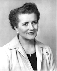

COYA KNUTSON
In 1950 Mrs. Coya Knutson, a high school instructor in Oklee and the wife of a local farmer and hotel operator, was elected to the State Legislature where she served the people of the 65th District in Minnesota for three terms.In 1956 she further distinquished herself and focused the attention of Oklee and the entire country by becoming the first woman from the State of Minnesota to be elected by the people of the 9th District to the Congress of the United States where she served for two terms in the House of Representatives. While there, her ceaseless and tireless efforts in helping to enact the National Defense Education Act, won for her the grateful appreciation of thousands of our young college students and their parents. The Act not only set up a student loan program which provided funds for promisi~and needy college students who otherwise might find it impossible to attend school, but also funds to local schools, like Oklee, to help improve the learning and teaching situation.
ST. FRANCIS XAVIER CATHOLIC CHURCH
St. Francis Xavier Church was built in Lambert Township under the pastor Father J. Archambault. The structure measured 40 X 90 and the cost was $3,800.
In 1917 the church was moved to its present site in Oklee. Major improvements were made when Father Charles Trudeau was the pastor from 1929 to 1932. Beautiful stained glass windows were installed at a cost of $75 each. Many
more improvements were made from 1932 until 1952 while Father Keough Patnode served as pastor -a parish kitchen and winter chapel were added, new pews and the pipe organ installed. The new rectory was built in 1958. In 1972 a new addition was built on the front of the church.
Land for the first St. Francis Cemetery, chapel and rectory was donated by Pierre Belland in 1899 in the original location in the Town of Lambert. This cemetery was used until 1915 when land was donated by Joseph Bergeron for the new and present cemetery near the church.
OKLEE
Population of Oklee 441
Population of Lambert Township 187
d. OTHER ? ? ?
STOP #5. Clearwater Church - Churches of Red Lake County
DIRECTIONS from Oklee: 4 miles north on #5, 4 miles east on county
Rd #1, 1 1/2 miles north on county Rd. #10
STOP # 6 Indian Reservation Land Rush
STOP #7 Roland Country Store - Country Stores of Red Lake
County
STOP #8 The farm of . . . . . . . - Century Farms in Red Lake County
For a list of Red Lake County Century farms see: centuryfarms.htm
STOP #9 Plummer
a. mill