|
|
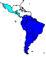
GEOG 332LATIN AMERICAPanama Canal: Interocean Link |
There are numerous Panama Canal Sites on the world wide web. Here I have organized them in an order that roughly corresponds to Dr. Dillman's lectures. Use the "BACK" button on your browser to return to this page after visiting these sites.
| Location | History | Size | Trivia | Trip from Caribbean to the Pacific | Colon Free Zone | Port of Cristobal | Gatun Locks | Gatun Lake | Gamboa | Madden Dam | Gaillard Cut | San Pedro Locks | Miraflores Lake | Miraflores Locks | Balboa Port | Links |
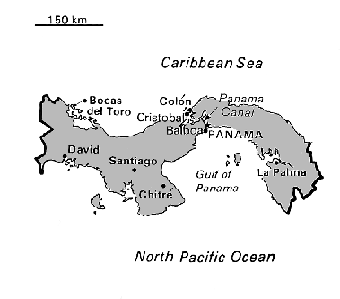
The Panama Canal, connecting the Pacific and Atlantic Oceans (via the Caribbean) runs in a northwest to southeast direction (see http://www.pananet.com/pancanal/INTERMAP.GIF ) through the country of Panama.
A 1-2 page brief history of the Panama Canal from the Panama Canal Commission (PCC). http://www.pananet.com/pancanal/public/history/history1.htm
A slightly different history: http://holly.colostate.edu/~panama/section7.html
Two student papers on the canal:
http://www.usmma.edu/CURR/DMT/Delaney.htm
http://www.usmma.edu/CURR/DMT/lugpomp.htm
DIMENSIONS FOR VESSELS:
http://www.pananet.com/pancanal/public/operat/dimen/dimensio.htm
A 2 page description from the PCC:
http://www.pananet.com/pancanal/public/general/features/features.htm
A list of fun facts from the PCC: http://www.pananet.com/pancanal/public/general/know.htm
The Panama Canal in profile: http://www.pananet.com/pancanal/public/profile.htm
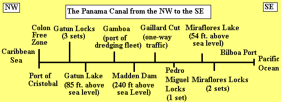
"A ship that transits the Canal from the Atlantic to the Pacific enters the channel from Limon Bay at the Cristobal breakwater. . . This sea-level section of the Canal channel on the Atlantic side is 10.5 kilometers (6-1/2 miles) long and 152.4 meters (500 feet) wide and runs through a mangrove swamp that is only a few feet above sea level in most places. " (From the Panama Canal Commission web site: http://www.pananet.com/pancanal/public/general/features/features.htm)
Brief description:
http://www.panamainfo.com/tables/pa_prt_cristobal.html
Location:
http://www.pananet.com/pancanal/INTERMAP.GIF
Brief description of the Zone:
http://www.iaehv.nl/users/grimaldo/news.html#freetrade
Also see:
http://www.panamainfo.com/tables/cfz_cfz_facts.html
More information than you want: http://www.panamainfo.com/tables/industry_cfz.html
Information and pictures from the city of Colon: http://www.pananet.com/turismo/colon/coloni.html
"A ship is raised or lowered 26 meters (85 feet) in a continuous flight of three steps at Gatun Locks. Each lock chamber is 33.5 meters (110 feet) wide and 306 meters (1,000 feet) long. The length of Gatun Locks, including the two approach walls, is 1.9 kilometers (1-1/5 miles). " (From the Panama Canal Commission web site: http://www.pananet.com/pancanal/public/general/features/features.htm)
Picture:
http://www.pananet.com/pancanal/public/galocks.htm
"Mule" positioning ship in the locks:
http://hp877.odedodea.edu:8001/panama/SHIP1.jpg
Location:
http://www.pananet.com/pancanal/INTERMAP.GIF
"Gatun Lake, through which the ships travel for 37.6 kilometers (23-1/2 miles) from Gatun Locks to the north end of Gaillard Cut, covers an area of 418.25 square kilometers (163.38 square miles) and was formed by the construction of Gatun Dam across the Chagres River adjacent to Gatun Locks. The two wings of the dam and the spillway have an aggregate length of about 2.4 kilometers (1-1/2 miles). The dam is nearly a half mile wide at the base, tapering to a width of 30.5 meters(100 feet) at the crest, which is 32 meters (105 feet) above sea level, or 6.1 meters (20 feet) above the normal level of Gatun Lake. "(From the Panama Canal Commission web site: http://www.pananet.com/pancanal/public/general/features/features.htm)
Picture:
http://www.pananet.com/pancanal/public/galake.htm
Location:
http://www.pananet.com/pancanal/INTERMAP.GIF
Gamboa is the home port for the canal's dredging fleet. Deforestation in the Canal Zone area has increased the need for continual dredging ( location).
The Rio Chagres:
http://www.great-adventures.com/adventure/riochagres.html
Location:
http://www.pananet.com/pancanal/INTERMAP.GIF
"This portion of the channel is about 13.7 kilometers (8-1/2 miles) long and was carved through rock and shale for most of the distance. It was here that the principal excavation was required and here that devastating slides occurred during construction and soon after the Canal was opened." (From the Panama Canal Commission web site: http://www.pananet.com/pancanal/public/general/features/features.htm) For more information on the Gaillard go to this Panama Canal commission site now.
Picture w/ text:
http://www.pananet.com/pancanal/public/gaicut.htm
Picture:
http://hp877.odedodea.edu:8001/panama/CANAL1.jpg
Location:
http://www.pananet.com/pancanal/INTERMAP.GIF
A Pacific-bound ship enters Pedro Miguel Locks at the south end of Gaillard Cut. Here it is lowered 9.4 meters (31 feet) in one step to Miraflores Lake. . . . The length of Pedro Miguel Locks is 0.27 kilometers (5/6 of a mile). (From the Panama Canal Commission web site: http://www.pananet.com/pancanal/public/general/features/features.htm)
Picture:
http://www.pananet.com/pancanal/public/pelocks.htm
Location:
http://www.pananet.com/pancanal/INTERMAP.GIF
Miraflores Lake is an artificial lake about a mile wide. It is located between the Miraflores and Pedro Miguel Locks and is 54 feet above the Pacific Ocean. (Location: http://www.pananet.com/pancanal/FOTO-7.JPG)
"A transiting ship is lowered the remaining two steps to sea level at Miraflores Locks, which is slightly over 1.6 kilometers (1 mile) in length. The lock gates at Miraflores are the tallest of any in the system because of the extreme tidal variation in the Pacific Ocean. " (From the Panama Canal Commission web site: http://www.pananet.com/pancanal/public/general/features/features.htm)
Picture from the air:
http://www.iaehv.nl/users/grimaldo/gif/canal.gif
Picture: http://www.pananet.com/pancanal/public/milocks.htm
Picture:
http://hp877.odedodea.edu:8001/panama/MIRA2.jpg
Picture:
http://hp877.odedodea.edu:8001/panama/MIRAFLOR.jpg
Several Pictures (click on pictures to enlarge):
http://hp877.odedodea.edu:8001/panama/miraflores.html
Location: http://www.pananet.com/pancanal/INTERMAP.GIF
Picture: http://www.pananet.com/pancanal/public/admphoto.htm
Panama
Home Page Section 7 (Panama canal Section)
Panama
Home Page Section 10 (Links to other Panama pages)
The
Panama Canal - Picture Miraflores Locks
Panama
Canal Commission
Pictures from the Panama Canal commission
http://www.pananet.com/pancanal/public/pictures.htm
PCC
Public and General Information
Index
of /panama/ List of JPEG photos
QUIZZES
- on-line quiz
The
Panama Canal - on-line quiz
The
Panama Canal - Royal Princess Cruise Lines
Panama
Canal - student paper
Panama
Canal - student paper (Delaney)
Panama
Canal - pictures of Miraflores Locks, mules
Online Newspapers from Panama:
http://www.iaehv.nl/users/grimaldo/news.html
Business information about Panama:
http://www.panamainfo.com/index.html
Panama:
http://lazarus.elte.hu/~zetor/cia95/pm.html