GEG 100
ONLINE!
Cultural
Geography
WEEK 12 - INSTRUCTOR NOTES
AND VOCABULARY
AGRICULTURE
|
|
|
READING ASSIGNMENTS
Read Chapter 10 Agriculture - All 4 Key Issues
VOCABULARY
For Vocabulary list and links click here
MODELS
|
Agriculture Location Models Chapter 10 |
Industrial Location Models Chapter 11 |
Location of Services Chapter 12 |
Urban Structure - the location of things within an urban area Chapter 13 |
|
|
|
|
- What is a "geographic model"?
- Models are simplifications of reality created to study geographic processes. Some models help us understand why things are located where they are.
- To simplify the real world scientist use various assumptions. Even though a model may be unrealistic, it can be quite useful in isolating and understanding different geography principles and processes
- How are geographic models expressed?
- graphs
- maps
- drawings
- mathematically
- Examples
- Some models are expressed as graphs. The Demographic
Transition Model in the chapter on population (week 3/chapter
2) uses a graph to explain changes in population growth rates .
-
Demographic Transition Model
week 3/chapter 2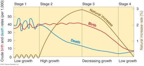
Weber's Model of transportation costs for a weight-losing industry
week 13/chapter 11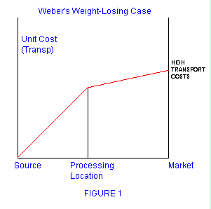
-
- Other models are expressed as simplified maps. Most of the
geographic models in this unit (see the box above) are
expressed this way (see figures below).
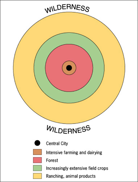
Von Thunen Model of the location of crops surrounding a central city (week 12/chapter 10) 
Multiple Nuclei Model of the location of activities with an urban area (week 14/chapter 13) 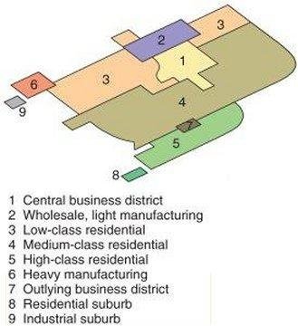
- Some models are expressed as drawings (see figures below).
Central Place Theory used to explain Hierarchy of Services and Settlements
week 14/chapter 12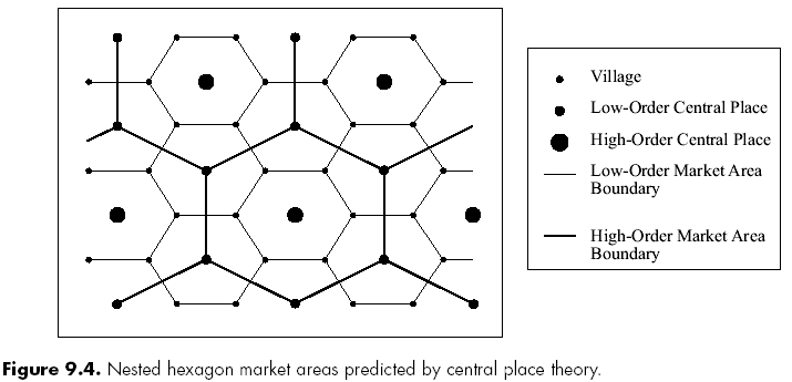
Hotelling's Model of where tertiary, or service, activities will locate
week 14/chapter 12
- In advanced geography classes models are expressed mathematically.
- Some models are expressed as graphs. The Demographic
Transition Model in the chapter on population (week 3/chapter
2) uses a graph to explain changes in population growth rates .
- Read: http://www.uwsp.edu/geo/faculty/ritter/geog101/textbook/essentials/models.html
- Don't worry. These models will make more sense after we study them.
- The REVIEW link on our Blackboard site has a "Unit 3 - Practice Quiz on Geographic Models"
KEY ISSUES
- Where did agriculture originate?
- Where are agricultural regions in LDSs?
- Where are agricultural regions in LDCs?
- Why do farmers face economic difficulties?
INTRODUCTION
- More than 40% of the people in the world are farmers.
- Approximately 1/2 of the people of LDCs are farmers
- Fewer than 2% of the people of the United States are farmers.
In unit 3 we study economic geography. The economy is an important part of culture. Since this is a geography course we will study WHERE economic activity takes place and WHY THERE. In the next three chapters we will study the three different types of economic activities:
- Week 12 - Primary Activities = Agriculture = Chapter 10
- Week 13 - Secondary Activities = Industry (Manufacturing) = Chapter 11
- Week 14 - Tertiary Activities = Service Sector and Urban Patterns = chapters 12 and 13
More than 40% of the world's population are farmers, but only 3.2% of GDP comes from agriculture (http://earthtrends.wri.org)
Since most of you are not farmers, you will have some new agriculture vocabulary to learn. Also keep in mind that since this is a geography class we will be focusing on the following questions about agriculture:
- Where?
- Why there?, and
- Why do we care?
The third question can be answered by a sign that I have seen in rural Wisconsin:
If you eat, you are part of
agriculture.
OUTLINE
- Key Issue 1: Where Did Agriculture Originate?
- Origins of agriculture
- Subsistence and Commercial Agriculture
- Mapping agricultural regions (extra)
- Key Issue 2: Where Are Agricultural Regions in Less
Developed Countries?
- Shifting cultivation
- Pastoral nomadism
- Intensive subsistence agriculture
- Plantation farming
- Key Issue 3: Where Are Agricultural Regions in More
Developed Countries?
- Mixed crop and livestock farming
- Dairy farming
- Grain farming
- Livestock ranching
- Mediterranean agriculture
- Commercial gardening and fruit farming
- Key Issue 4: Why Do Farmers Face Economic Difficulties
- Challenges for commercial farmers
- Challenges for subsistence farmers
- Strategies to increase food supply
KEY ISSUE 1: WHERE DID AGRICULTURE ORIGINATE?
Origins of Agriculture
- Basic definitions:
- What is "agriculture"? -- "deliberate modification of Earth's surface through cultivation of plants and rearing animals to obtain sustenance or economic gain"
- What is a "crop"? - any plant cultivated (cared for) by people
- Hunters and Gatherers
- before the invention of agriculture all humans obtained food from gathering plants that grew wild and from hunting wild animals
- hunting an gathering required small human populations because larger populaiton would exhaust all of the availabe wild plants and animals
- gender-based division of labor: men hunted and women gathered
- often finding or killing food only took up a small part of the day
- nomadic - small groups of people traveled frequently to find food
- Hunting and Gathering Today
- about 250,000 people live this way (0.005% of world's population)
- exists only in the arctic or interior areas of Africa, Australia, and South America, and the Pacific islands
- Examples:
- Spinifex people of Australia's Great Victoria Desert
- Sentinelese people of India's Andaman Islands
- Bushmen of Botswana and Namibia, Africa,
- Invention of Agriculture
- Scientists tend to disagrre on WHEN or WHY agriculture began
- but they do agree on WHERE it began - agriculture probably originated in multiple areas, called "hearths" (see map below)
- Two Types of Cultivation
- FIRST: vegetative planting - reproduction of plants by direct cloning from existing plants, such as cutting stems and dividing roots
- LATER: seed agriculture - reproduction of plants through annual planting of seeds that result from sexual fertilization
- Locations of First Vegetative Planting
- probably first originated in Southeast Asia
- why there?
- availability of fishing allowed for a more sedentary lifestyle
- appropriate climate and topography for vegetative planting
- probably root crops like taro and yams and tree crops like banana and palm
- probably also domesticated the dog, pig, and chicken
- why there?
- other vegetative planting hearths
- West Africa
- Andean (northwestern) South America
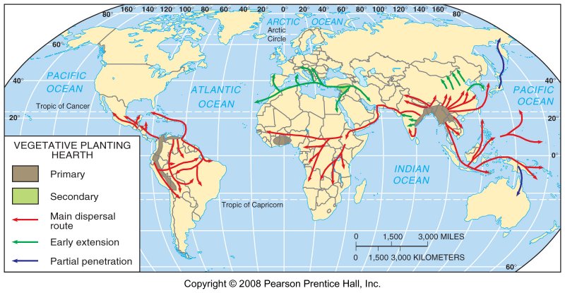
- probably first originated in Southeast Asia
- Locations of First Seed Agriculture
- Eastern hemisphere hearths (wheat, barley)
- southwest Asia
- southeast Asia
- western India
- northern China
- Ethiopia
- Western hemisphere hearths
- southern Mexico (squash and maize [corn])
- northern Peru (squash, beans, cotton)
- llama, alpaca, turkey
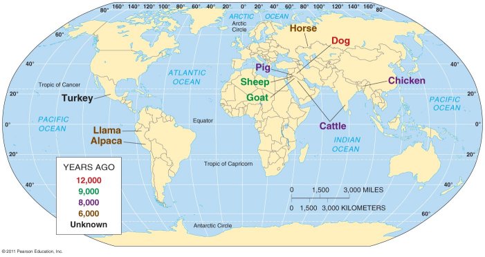
- Domestication of Animals
- animals were also domesticated in multiple hearths at various dates (see map below)
- Southwest Asia
- probably domesticated the largest number of important agricutural animals: cattle, goats, pigs, and sheep
- around 8,000 to 9,000 years ago
- also domesticated the dog
- Southwest Asia was probably where seed agriculture was integrated with the domestication of animals where animals were used to grow crops
- horse was probably domesticated in Central Asia (recall the Kurgan Hypothesis for the diffusion of Indo-European languages, week 9, chapter 5)
Subsistence and Commercial Agriculture
- Two main
agricultural types:
- Percentage of Farmers in the Labor Force
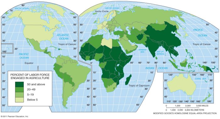
Note the same pattern that we saw in the previous chapter where Africa was the most least developed region with the greatest % of the labor force working as farmers, followed by South, East, and Southeast Asia, then Southwest Asia and North Africa and finally Latin America is the most developed of the LDC regions. North America and Europe are the most developed regions with the smallest % of the labor force in agriculture.
- Percentage of Farmers in the Labor Force
Mapping agricultural regions:
WHERE ARE DIFFERENT PRODUCTS PRODUCED
AND WHY THERE?
AND WHY THERE?
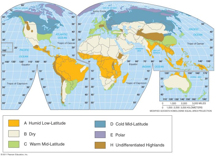
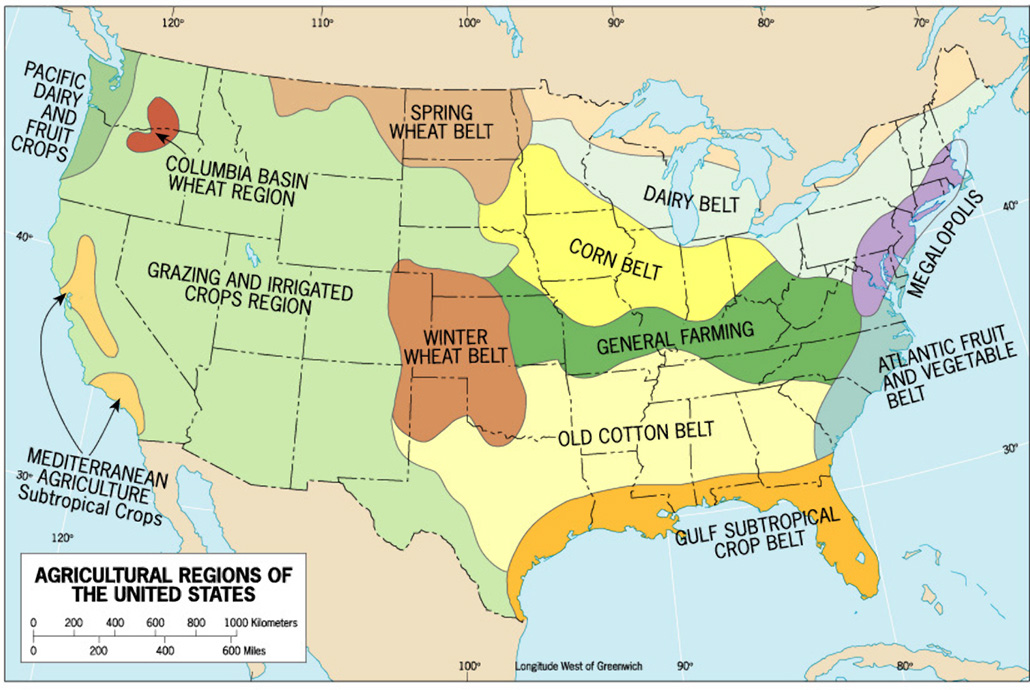
- much is based on climate - compare the climate map and the agricultural regions map found below and in the textbook's figure 10-5.
- some is based on cultural preferences
- much depends on the level of economic development (LDC or MDC)
See the table below.
- There is not a perfect correlation between the LDCs/MDCs and these agricultural regions.
- We will find some agricultural regions that are USUALLY found in MDCs are also sometimes found in LDCs and vice versa.
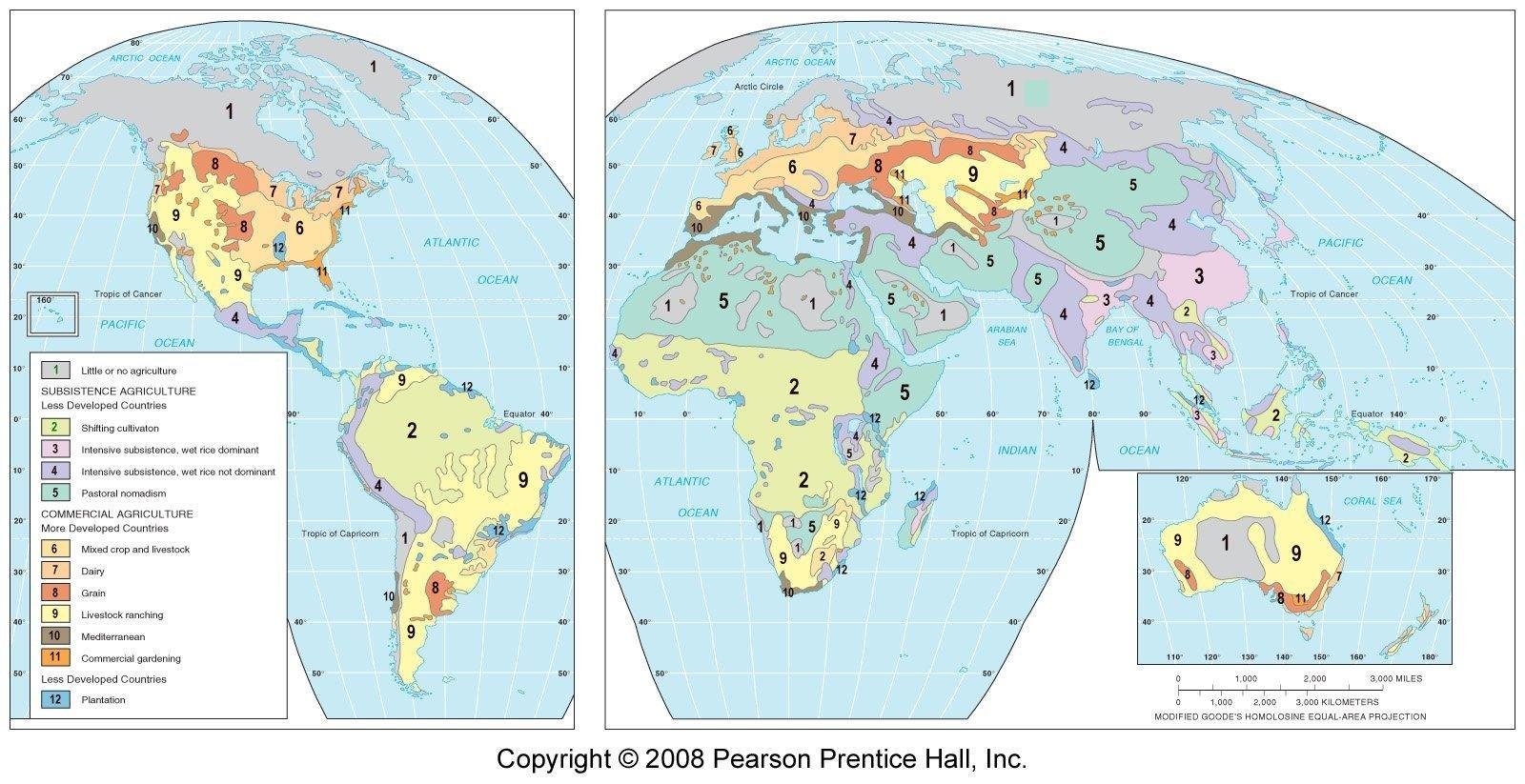
These agricultural regions will be described below in Key Issues 2 and 3.What Are the Agricultural Regions Found in Less Developed Countries? (number) refers to the map below.
Subsistence Agricultural Regions:
- Shifting cultivation (2)
- Pastoral nomadism (3)
- Intensive subsistence: wet rice dominant (4)
- Intensive subsistence: crops other than rice (5)
- Plantation farming (12)
What Are Agricultural Regions Found in More Developed Countries? (number) refers to the map below.
Commercial Agricultural Regions:
- Mixed crop and livestock farming (6)
- Dairy farming (7)
- Grain farming (8)
- Livestock ranching (9)
- Mediterranean agriculture (10)
- Commercial gardening and fruit farming (11)
"Map #" refers to the map below.
AGRICULTURAL REGION MAP #
LOCATIONS CLIMATE
TYPECROPS / PRODUCT Subsistence Regions:
usually LDCs|
|
|
|
shifting cultivation
2 primarily tropical regions of South America, Africa, and Asia
A rice, maize (corn), manioc (cassava), millet, sorghum, others
pastoral nomadism
3 drylands of North Africa and Southeast Asia
B camel, sheep, goats, horse, cattle
intensive subsistence wet rice dominant
4 primarily large population concentrations of East and South Asia
C and A rice
intensive subsistence - crops other than rice
5 primarily the large population concentrations of East and South Asia where growing rice is difficult
D wheat, barley, others
plantations
(commercial agriculture, not subsistence, but usually found in LDCs)12 primarily the tropical and subtropical regions of Latin America, Africa, and Asia
A cotton, sugarcane, coffee, rubber, tobacco, others
Commercial Regions:
usually MDCsMAP #
LOCATIONS CLIMATE
TYPECROPS / PRODUCT mixed crop and livestock
6 primarily U.S. Midwest and central Europe
C corn, pigs, cattle, soybeans
dairying
7 primarily near population clusters in northeastern U.S., southeastern Canada, and northwestern Europe
C and D milk (closer to urban areas), butter, cheese, and dry milk further from urban areas
grain
8 primarily north-central U.S. and Eastern Europe
D winter wheat, spring wheat
ranching
9 primarily drylands of western U.S., southeastern South America, Central Asia, southern Africa, and Australia
B cattle, sheep
Mediterranean
10 primarily lands surrounding the Mediterranean Sea, western U.S., and Chile
C olives, grapes, fruits, vegetables, wheat
commercial gardening
11 primarily southeastern U.S. and southeastern Australia
C fruits and vegetables
Little or No Agriculture
1
deserts or cold polar regions
B and E none
MAPS - AGRICULTURAL REGIONS AND CLIMATIC REGIONS (Figure 10-4)
Key Issue 2: Where Are Agricultural Regions in LDCs?
- Shifting cultivation (2)
- Pastoral nomadism (3)
- Intensive subsistence: wet rice dominant (4)
- Intensive subsistence: crops other than rice (5)
- Plantation farming (12)
- also called "slash and burn", "swidden", ladang, milpa, chena, kaingin
- found in "A" (tropical) climate regions with high temperatures and abundant rainfall;
- because of the high amounts of rain the soils leached of nutrients (therefore infertile soils)
- 250 million farmers on 14 million square miles;
- 25% of the world's land area
- for 5% of the world's people
- therefore there is a very low population density in areas where shifting cultivation is practiced
- WHERE - tropical rainforests of South America, Central and West Africa, and Southeast Asia
- Process:
- an area of the forest is cleared with axes and the debris is burned providing nutrients to the soil - such a cleared and burned field is called "swidden"
- small fields are prepared by hand and planted
- cleared land can support crops for only a few years, usually 3 years, and soil nutrients are rapidly depleted
- the plot is then abandoned and another area is cleared and the process starts over again
- land is left without crops for 20 years or longer to allow nutrients to return to the soil
- with increase population pressures they may have to return to a field sooner before its soils have had a chance to replenish
- Crops of shifting cultivation:
- rice in Southeast Asia
- maize and manioc in South America
- millet and sorghum in Africa
- also yams, sugarcane, plantain, and vegetables
- crops are often intermingled in the same area, certain crops a placed in certain areas to promote their growth
- ownership and use of land in shifting cultivation:
- traditionally, land is owned communally by the whole village
- a leader allocates land to each family
- private land ownership is becoming more popular especially in Latin America
- requires a large area with few people
- 25% of the world's land area, a higher % than any other type of agriculture
- 5% of the world's people
- The future of shifting cultivation
- land used for shifting cultivation is declining about 0.2% every year
- the amount of land used for shifting cultivation (mostly tropical rain forests) is now less than half of what it was
- being replaced by logging, cattle ranching, and cultivation of cash crops
- defenders of the practice argue that it is environmentally sound and sustainable as long as population density is low since only a small area is cleared and most of the forest is left to regrow
- form of subsistence agriculture based on the herding of domesticated animals
- often (but not always) found in B (dry) climates of North Africa, Southwest Asia, and parts of Central Asia
- about 15 million people (0.25% of world population) on 20% of Earth's land area; low population density
- animals provide milk and blood for food and skins and hair for cloth and tents
- most sustenance comes from grain either grown by part of the nomadic group or obtained from sedentary subsistence farmers through trade
- choice of animals:
- camels in North Africa
- horse in central Asia
- also sheep and goats
- the typival nomadic family needs 25 to 60 goats or sheep or 10 to 25 camels
- movements:
- not random
- each group controls a certain area
- migration routes depend on a variety of variables especially sources of water
- Some groups practice transhumance - seasonal migration of livestock between mountains and lowlands pasture areas
- Pasture
- an area covered with grass or other plants used or suitable for the grazing of livestock; grassland.
- and the grass or other plants for feeding livestock.
- future of pastoral nomadism
- a practical way of surviving on land that receives too little rain for the cultivation of crops
- but, declining
- often government try to get the nomads to settle down to free the land for other uses like irrigated agriculture, mining, and petroleum
Intensive Subsistence Agriculture
- Definition: a form of subsistence agriculture in which farmers must expend a relatively large amount of effort to produce the maximum feasible yield from a parcel of land
- often in very densely populated areas of East, South, and Southeast Asia (see map above)
- farms tend to be small requiring careful and intensive use of the land to provide enough food for the family
- most work is done by hand or with animals
- two general types:
- wet rice dominant
- wet rice NOT dominant
- Intensive
Subsistence Agriculture with Wet Rice Dominant
- wet rice - planting rice on dryland in a nursery then moving the seedlings to a flooded field
- Southeast China, East India, and much of Southeast Asia
- often A and C climatic regions
- small amount of land but major source of food
- heavily labor intensive
- growing rice involves several steps
- field plowed, often with animal power
- field flooded, now called a sawah in Indonesia or paddy by Europeans and North Americans
- seedlings planted or seeds scattered
- the sawah (paddy) is drained and the plants harvested by hand, and threshed to separate the chaff from the seeds and then winnowed to get rid of the lighter chaff
- the hull must be removed by mortar and pestle prior to cooking
- flat land or terracing needed to form the paddies
- double cropping - getting two crops a year from the same piece of land - modt often with other crops - is possible in south China and Taiwan, but rare in South Asia
- Intensive Subsistence Agriculture
with Wet Rice NOT Dominant
- areas with too little precipitation for rice and harsher winters
- often D climates
- interior of India, northeast China, southern Mexico, Andes mountains of South America, parts of east Africa
- wheat is the most important crop, followed by barley
- other crops include millet, oats, corn, kaoling, sorghum, and soybeans and cash crops like cotton, flax, hemp, and tobacco
- land is used intensively as in wet rice dominant areas
- crop rotation - the practice of rotating use of different fields from crop to crop each year to avoid exhausting the soil of nutrients
- form of commercial agriculture found in topical and subtropical LDCs
- a plantation is a large farm that specializes in one or two commercial crops
- including cotton, sugarcane, coffee, rubber, and tobacco, and others
- generally located in LDCs but owned by Europeans or North Americans
- products are usually sold to MDCs
- often in sparse populated areas and need to import worker
- usually A climates
- often foreign owned
- cotton and tobacco plantations were common in the southern US
KEY ISSUE 3: WHERE ARE AGRICULTURAL REGIONS IN MDCs?
- Mixed crop and livestock farming (6)
- Dairy farming (7)
- Grain farming (8)
- Livestock ranching (9)
- Mediterranean agriculture (10)
- Commercial gardening and fruit farming (11)
Mixed Crop and Livestock Farming
- U.S. between the Great Plains and the Appalachian Mountains, Europe from France to Russia
- integration of crops and livestock
- most of the crops are fed to livestock but some sold for human consumption
- more even distribution of work and income throughout the year
- Crops: Corn and Soybeans - U.S. Corn Belt from Ohio to the Dakotas
- Livestock: Cattle, Pigs
Dairy Farming
- North East U.S., Southeast Canada, northwest Europe, usually near large urban areas
- less dominant in LDCs, but growing rapidly
- LDCs produced 44% of dairy products in 2005 while accounting for about 75% of the world's population
- India is now the world's largest milk producer
- Why near urban areas?
- close to market because milk is highly perishable
- milkshed - the ring surrounding a city from which milk can be supplied without spoiling
- milksheds have grown with improved transportation methods
- if dairy farm is further from urban area, more likely milk
is used to produce butter, cheese, or dried milk, rather than
fresh milk
- most milk produced in Wisconsin is processed into other products; most milk produced in Pennsylvania near large urban areas is sold directly as milk
- New Zealand, far from large markets processed 95% of its milk; dairy farmers in the United Kingdom process only half
- milk production is labor intensive
- Grain is the seed from various grasses like wheat, corn, oats, barley, millets, others
- grown primarily for direct human consumption, unlike mixed crop and livestock farming
- crop sold to manufacturers of food products
- most important crop is wheat generally used to make bread
- generally grown in D climates; areas too dry for mixed crop and livestock
- west of the Mississippi River in the US and in southern Russia
- winter wheat
- planted in the fall, survives the winter, harvested late the next summer
- Kansas, Colorado, Oklahoma
- spring wheat
- planted in the spring and harvested in the fall
- Dakotas, Montana, southern Saskatchewan, Washington
- Ranching is the commercial grazing of livestock over an extensive area
- usually in B (dry) climate areas too dry for grain farming
- western U.S., Central Asian steppes, southern South America (as well as Argentina and Brazil), Australia (sheep)
- cattle, sheep, goats
- open range vs. fixed location ranching
Mediterranean Agriculture
- around the Mediterranean Sea, California, Chile, South Africa
- hilly coastal areas with moist moderate winters followed by hot dry summers usually on the west side of continents
- most crops grown for human consumption
- olives, grapes, and horticulture (growing of fruits, vegetables, and flowers)
- limited livestock raising, transhumance with sheep and goats grazing near the sea in the winter and brought up the mountains in the summer
- wine production
- also grain production (up to half the land) wheat (pasta)
Commercial Gardening and Fruit Farming
- U.S. Southeast
- long growing season with humid climate accessible to large population areas
- called truck farming
- fruits and vegetables
TEST YOURSELF
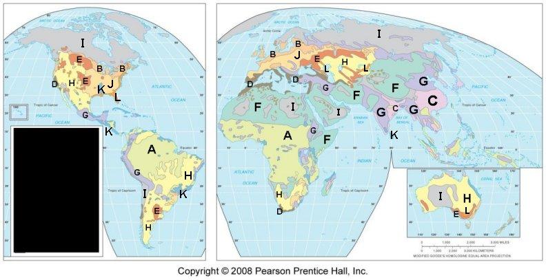
Matching: Match the area on the map above wioth the agriccultural region from the list below.
- Shifting cultivation
- Pastoral nomadism
- Intensive subsistence: wet rice dominant
- Intensive subsistence: crops other than rice
- Plantation farming
- Mixed crop and livestock farming
- Dairy farming
- Grain farming
- Livestock ranching
- Mediterranean agriculture
- Commercial gardening and fruit farming
- Little or no agriculture
- _____
- _____
- _____
- _____
- _____
- _____
- _____
- _____
- _____
- _____
- _____
- _____
KEY ISSUE: WHY DO FARMERS FACE ECONOMIC DFFICULTIES?
- Challenges for Commercial Farmers
- importance of access to markets
- overproduction
- Sustainable agriculture
- Challenges for Subsistence Farmers
- subsistence farming and populaiton growth
- subsistence farming and internatinal trade
- Strategies to Increase the Food Supply
- expanding agricultural land
- increasing productivitiy
- indentifying new food sources
- increasing trade
Challenges for Commercial Farmers
- Importance of Access to Markets
- In the discussion of dairy farming and truck farming above mention was made to the importance of "access to markets" or "close to urban areas" for these perishable products
- Von Thunen Model

- Overproduction in commercial farming
- "Commercial farmers suffer from low incomes because they
are capable of producing much more food than is demanded by
consumers in MDCs"
- increases in productivity
- low population growth
- US government policies to help:
- policies designed to discourage overproduction (e.g.. planting fallow crops to reduce soil erosion)
- government pays farmers when certain commodity prices are low (guaranteeing a target price)
- government buys surplus production and offers food stamps to low income American to increase demand for food
- Farming in Europe is subsidized even more than in the U.S.
- "Commercial farmers suffer from low incomes because they
are capable of producing much more food than is demanded by
consumers in MDCs"
- Sustainable agriculture
- an agricultural practice that preserves and enhances environmental quality including organic farming
- includes
- sensitive land management like ridge tilling
- limited use of chemicals
- better integration of crops and livestock
Challenges for Subsistence Farmers
- Subsistence farming and population growth
- Two approaches to increasing production to provide more
food for growing populations
- leave land fallow for shorter periods; fallow - land left unseeded during a growing season
- adopting new farming methods
- Two approaches to increasing production to provide more
food for growing populations
- Subsistence farming and international trade
- with modern agricultural techniques, farmers in LDCs need to buy (usually imported) agricultural input like fertilizers, pesticides, machinery
- to earn money to pay for such inputs they need to produce more for sale
- drug crops
- largest drug crop: marijuana
- OPIUM: textbook out-of-date: the textbook states that 60% of opium, the crop from which heroine is made, is grown in the "golden triangle" in Burma, Laos, Thailand, and Vietnam, BUT now over 90% is grown in Afghanistan
- COCA: from which cocaine is made is grown primarily in northwestern South America - Bolivia, Colombia, and Peru produce 98%
- MARIJUANA: cultivated widely around the world
- Drug Crops
Strategies to Increase Food Supply
- Strategies:
- expanding land area for agricultural use
- higher productivity
- identifying new food sources
- increasing trade
- expanding land area for agricultural use
- historically how food production was increased to meet the demands of larger populations
- now, population is increasing faster than the increase in agricultural land
- although there are some areas where agricultural land can
expand, in other areas land area available for agriculture is
decreasing due to:
- lack of water and desertification
- excessive irrigation water logging the land
- urbanization
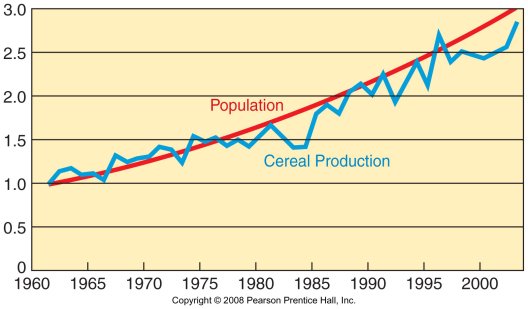
- higher productivity - the Green
Revolution
- the invention and rapid diffusion of more productive agricultural techniques during the 1970s and 1980s
- two main practices:
- invention and introduction of higher yielding variety (HYV) seeds
- expanded use of fertilizer
- HYV of wheat (first) then rice were invented, later corn (maize)
- Results:
- India's wheat production more than doubled in 5 years
- the green revolution was largely responsible for preventing a food crisis during the 1970s and 1980s
- identifying new food sources - three strategies being
considered
- cultivate oceans - fish
- develop high protein cereals
- improve palatability of rarely consumed foods e.g.. soybeans (most fed to animals rather than directly consumed by humans) and krill
- increasing exports from other countries
- the U.S. is the world's leading exporter of grain
- by 1980 North America was the world's only major food exporting region
- but things have changed
- South Asia and Southeast Asia are now also major exporters
- RICE: Thailand is now the world's largest exporter of rice (1/3 of world's rice exports), followed by India, U.S., Vietnam, and Pakistan in fifth place
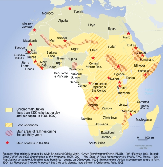
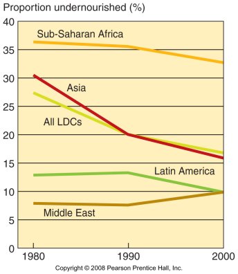
- Case Study: Africa's Food-Supply Crisis (p. 339-340)
|
|
VOCABULARY
See list of "Key Terms" at the end of the chapter in the textbook.
There may be additional terms not on the list of Key Terms listed below:
|